Tree cover, tree height and bare soil cover differences along a land use degradation gradient in semi-arid savannas, South Africa
JavaScript is disabled for your browser. Some features of this site may not work without it.
- ResearchSpace
- →
- Research Publications/Outputs
- →
- Conference Publications
- →
- View Item
| dc.contributor.author |
Mathieu, Renaud SA

|
|
| dc.contributor.author |
Wessels, Konrad J
|
|
| dc.contributor.author |
Asner, G
|
|
| dc.contributor.author |
Knapp, D
|
|
| dc.contributor.author |
van Aardt, J
|
|
| dc.contributor.author |
Main, Russell S
|
|
| dc.contributor.author |
Cho, Moses A
|
|
| dc.contributor.author |
Erasmus, B
|
|
| dc.contributor.author |
Smit, I
|
|
| dc.date.accessioned | 2010-08-24T07:55:06Z | |
| dc.date.available | 2010-08-24T07:55:06Z | |
| dc.date.issued | 2009-07 | |
| dc.identifier.citation | Mathieu, R.S.A., Wessels, K.J., Asner, G., et al. 2009.Tree cover, tree height and bare soil cover differences along a land use degradation gradient in semi-arid savannas, South Africa.IEEE International Geoscience and Remote Sensing Symposium (IGARSS), Cape Town, South Africa, 12-17 July 2009, pp 194-197 | en |
| dc.identifier.isbn | 978-14244-33957 | |
| dc.identifier.isbn | 978-1-4244-3394-0 | |
| dc.identifier.issn | 2153-7003 | |
| dc.identifier.issn | 2153-6996 | |
| dc.identifier.uri | http://hdl.handle.net/10204/4202 | |
| dc.identifier.uri | https://ieeexplore.ieee.org/document/5418039 | |
| dc.identifier.uri | DOI: 10.1109/IGARSS.2009.5418039 | |
| dc.description | IEEE International Geoscience and Remote Sensing Symposium (IGARSS), Cape Town, South Africa, 12-17 July 2009. | en |
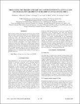
| dc.description.abstract | High resolution airborne hyperspectral and discrete return LiDAR data were used to assess bare soil and tree cover differences along a land use transect consisting of state-owned, privately-owned conservation areas, and communal areas in South African savannas. The results show that tree cover is higher in conservation areas as compared to communal areas where local people use fuel wood for personal consumption. Low impact communal sites (limited use) tend to have higher tree cover than higher impacted communal sites. Generally communal areas have altered tree height distribution but in diverse way depending on the geology or the level of human utilization. Bare soil cover was generally found to be quite low (10%) in all different land uses, suggesting that the degradation level in communal areas might not be as high as generally perceived. | en |
| dc.language.iso | en | en |
| dc.publisher | IEEE | en |
| dc.subject | Tree cover | en |
| dc.subject | Tree height | en |
| dc.subject | Bare soil cover | en |
| dc.subject | Land degradation | en |
| dc.subject | Semi arid Savannas | en |
| dc.subject | Hyperspectral | en |
| dc.subject | Liscrete return LiDAR data | en |
| dc.subject | South African savannas | en |
| dc.subject | Fuel wood | en |
| dc.subject | Geoscience | en |
| dc.subject | Remote sensing | en |
| dc.subject | IGARSS 2009 | en |
| dc.title | Tree cover, tree height and bare soil cover differences along a land use degradation gradient in semi-arid savannas, South Africa | en |
| dc.type | Conference Presentation | en |
| dc.identifier.apacitation | Mathieu, R. S., Wessels, K. J., Asner, G., Knapp, D., van Aardt, J., Main, R. S., ... Smit, I. (2009). Tree cover, tree height and bare soil cover differences along a land use degradation gradient in semi-arid savannas, South Africa. IEEE. http://hdl.handle.net/10204/4202 | en_ZA |
| dc.identifier.chicagocitation | Mathieu, Renaud SA, Konrad J Wessels, G Asner, D Knapp, J van Aardt, Russel S Main, Moses A Cho, B Erasmus, and I Smit. "Tree cover, tree height and bare soil cover differences along a land use degradation gradient in semi-arid savannas, South Africa." (2009): http://hdl.handle.net/10204/4202 | en_ZA |
| dc.identifier.vancouvercitation | Mathieu RS, Wessels KJ, Asner G, Knapp D, van Aardt J, Main RS, et al, Tree cover, tree height and bare soil cover differences along a land use degradation gradient in semi-arid savannas, South Africa; IEEE; 2009. http://hdl.handle.net/10204/4202 . | en_ZA |
| dc.identifier.ris | TY - Conference Presentation AU - Mathieu, Renaud SA AU - Wessels, Konrad J AU - Asner, G AU - Knapp, D AU - van Aardt, J AU - Main, Russel S AU - Cho, Moses A AU - Erasmus, B AU - Smit, I AB - High resolution airborne hyperspectral and discrete return LiDAR data were used to assess bare soil and tree cover differences along a land use transect consisting of state-owned, privately-owned conservation areas, and communal areas in South African savannas. The results show that tree cover is higher in conservation areas as compared to communal areas where local people use fuel wood for personal consumption. Low impact communal sites (limited use) tend to have higher tree cover than higher impacted communal sites. Generally communal areas have altered tree height distribution but in diverse way depending on the geology or the level of human utilization. Bare soil cover was generally found to be quite low (10%) in all different land uses, suggesting that the degradation level in communal areas might not be as high as generally perceived. DA - 2009-07 DB - ResearchSpace DP - CSIR KW - Tree cover KW - Tree height KW - Bare soil cover KW - Land degradation KW - Semi arid Savannas KW - Hyperspectral KW - Liscrete return LiDAR data KW - South African savannas KW - Fuel wood KW - Geoscience KW - Remote sensing KW - IGARSS 2009 LK - https://researchspace.csir.co.za PY - 2009 SM - 978-14244-33957 SM - 978-1-4244-3394-0 SM - 2153-7003 SM - 2153-6996 T1 - Tree cover, tree height and bare soil cover differences along a land use degradation gradient in semi-arid savannas, South Africa TI - Tree cover, tree height and bare soil cover differences along a land use degradation gradient in semi-arid savannas, South Africa UR - http://hdl.handle.net/10204/4202 ER - | en_ZA |